


By Gagandeep Ghuman
Published: Oct. 28, 2013
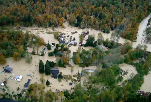
A local geoscientist is warning the district to update its obsolete Flood Hazard Management Plan (FHMP) to reflect current standards on dikes, development and climate change.
The district hasn’t reviewed its flood management plan in the last 19 years.
“The district sorely needs to update the plan, it’s a 1993 document based on flood records only current to 1976,” said geoscientist Pierre Friele.
Friele said the 19-year-old district flood management plan has been rendered obsolete by new flood records, such as the one Squamish witnessed in 2003.
He said new developments have also changed the Squamish topography, while dike elevations have also been altered.
“We are aware of dike weakness and we now have much better flood modelling tools,” he said.
Climate change needs to be considered, he added. Friele also said the district flood management plan was never adopted as a bylaw.
This enabled private developers, such as the one who bought property in Brackendale, to buy land on the river side if the dike.
“That was something not allowed by the flood hazard plan or by common sense!”
The district, however, says it’s not appropriate to review the plan too frequently, since it can create challenges for developers.
The district wasn’t too clear in its response for when it’s appropriate to review the plans.
At least the district is willing to admit that several aspects of the old plan are obsolete. According to the district, the 1994 plan made assumptions about the pattern of future development. New dike standards have been developed and coastal flood level criteria has changed in the last 19 years.
The district also concedes that the 1994 plans recommended floodplain bylaws be adopted, but that didn’t happen either.
The district is now getting serious about updating the flood management plan.
District spokesperson Moore said the process to hire a consultant will begin in 2014.
“The project is anticipated to take three years to complete and will involve extensive public consultation,” Moore said.
The district has budgeted $315,000 to update the plan.
In the absence of an updated plan, the district had to hire a consultant for some ‘interim guidance’ on flood management when a developer wanted to develop on the west side of the blind channel.
The consultant’s very first recommendations: Update the comprehensive flood hazard management plan as soon as possible.
The second one: defer a final decision on the primary dike alignment until the plan is updated.
The district may not have updated its master plan, but it has done substantial work in implementing flood management projects.
Some of the projects completed from 2008-13:
- Squamish River dike raising downstream of BC Rail bridge
- Stability assessment of the Squamish River dike
- Upper Squamish River Dike Erosion protection works
- Sediment management at Cheekye River and Mamquam River
- Repair of Squamish River dike sinkhole

Anyone with a very basic understanding of Geology/Hydrology should know that diking a river is a “Band-Aid”. Rivers bring down silt and as they widen toward the ocean the flow slows and deposition occurs. The water level rises (Archimedes bath tub principle) and so the restraining dikes will eventually have to be raised….But how high?…And can they be kept as strong at the top as at the bottom? Hemming in rivers is a very hard job. They like to meander and will eventually get their wish unless we spend a lot of effort and a lot of money! Also no dike should be privately owned so that the proper and timely maintenance can be performed.
Thanks Gagandeep – another excellent article!
One learns about endless numbers of expensive consultants – but are their recommendations followed?
I quote :
“The district, however, says it’s not appropriate to review the plan too frequently, since it can create challenges for developers.”
Does that statement not mean that these disclosures provide challenges for DoS?