By Gagandeep Ghuman
Published: Nov. 28, 2014
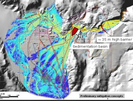
Proponents of a massive housing development in Brackendale plan to build a 35-metre high barrier and a sedimentation basin to protect the area from an extreme debris hazard flow event.
The proposed development is a partnership between Squamish Nation and local company Bethel Lands.
Their company, Cheekeye River Developments Ltd, wants to build 750 single-family housing units, a childcare facility, and a private school close to Ross Road in Brackendale.
The mitigation is for one in a 10,000 year event, which translates to 0.0001 per cent in any given year, according to Matthias Jakob, an engineer with BCG, the firm hired by the proponents to assess debris hazard in the Cheekeye Fan area.
Jakob spoke about the mitigation efforts at public information meeting organised by the district at the Brackendale Art Gallery on Nov. 26.
Without proper mitigation, this extreme event can dump 5.5 million cubic metres of debris in the area, enough to fill the BC Place stadium twice.
Mitigating for one-in-a-10,000 year debris flow event is being extra precautions; countries such as Switzerland have mitigation structures for one in a 500 year event only, Jacob said.
One of these barriers would be in the area known as upper fan, about one kilometre upstream of Highway 99. The other one, a sedimentation basin, would be constructed immediately upstream of Highway 99 near the Cheekeye River.
The development partners will pay for mitigation, but the district will be on the hook for the operational cost of mitigation structure.
Costs for the barriers haven’t been finalized yet.
Without a mitigation structure in place as of now, a debris flow event can impact the Brackendale Elememtary School, Don Ross Secondary, First Nation reserves, Highway 99, the airport, and current residential areas are at risk, Jakob said.
“Mitigation is required irrespective of this new development,” he said.
The proponents have applied to amend the district’s Official Community Plan and Zoning bylaw for this 178 acres site. The amendment would change designation from industrial to residential and greenway corridors to residential.

In 2011, local council signed an intergovernmental cooperation accord with the Squamish Nation, agreeing that the nation may apply to the province for the ownership of the 200 acres, including the dedication of 50 acres for a public park, and a 25 percent share in profits to the district.
In 2013, the district, the province and the Squamish Nation appointed an expert review panel to review past studies and provide independent opinion on hazard and mitigation.
Jenni Chancey, a representative for the developer, said the development will be built over 20 years and in two phases.
The lots size would vary: there will be 78 lots that will be 6000 square feet in size, 59 lots of 4500 square feet and 79 lots that will be 2850 square feet.
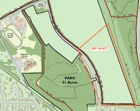
She said the development will provide for 57 acres of parkland, 51 acres of community parks and six acres of parkway. The developer also plans to have a provision for a school or a day care. There are also plans to extend the Ray Peters Trail.
“There will be a net gain of 2.2 kilometres,” she said.

As many as 100 residents attended the meeting and some took to the mike to express their concerns.
As many as 100 residents attended the meeting and some took to the mike to express their concerns. A Brackendale resident, Rachel Shephard, said the development and the mitigation should be looked at separately.
On the district’s website, residents worried the development would mean a loss of trails and forested area. Julia Black lives kitty-corner to the trail head on Ross Road. She said she was ‘deeply saddened’ to see the development sign posted.
After the family read the sign, Black’s seven year-old son cried for almost an hour.
“Doesn’t anyone love nature?!” he asked.


Eric Andersen says
“Cheekeye” is a misspelling of “Cheekye” — derived from Ch’kai – “the mountain (and creek) of dirty snow”.
Keith Sones says
Just so I understand, the proponents are required to install a 120 foot barrier to protect against a one in 10,000 year event. Just over 10,000 years ago, the valley was covered with a mile of ice. When Garibaldi blew its top last time, no man made feature was going to prevent the flow of lava or the complete removal of one side of the mountain. Whenever someone tells you they can predict a one in 10,000 year event, you only know two things. One, they are wildly wrong. Second, they likely stand to make a lot of money from putting the protective measures in place.
heather gee says
When an ‘extreme debris hazard flow’ event occurs, most of area up to downtown will be swept away. Do some research online on the rate at which the flow moves and what it carries with it. You don’t have to wonder why the barrier they are planning is 35 metres high. The agreement is in place only to protect their development – not what the entire area needs…. That responsibility has not been addressed.
Larry McLennan says
Actually Keith, your 10K ice sheet may, at least locally, have been non-existant. In October of 2007 , Johannes Koch , in a doctoral thesis at SFU, revealed that melting glaciers in Garibaldi Park had revealed in situ (in original location) tree stumps dating back only 7K years. ie it may have been warmer 7K years ago than it is now. Subsequent to the 7K era, the trees were covered in ice-apparently within a relatively short time period.
As to the 35 metre berm- IMO if the massive flow occurred (I have a BSc in Geology) that berm won’t do much to mitigate any damage- perhaps it would help in the case of some lesser degree of flow.
Tjay says
ALLLLL of Squamish is the same and affected…… so buzz off elitists !…….